
 MENU
MENU 

SMAP Update: A mission to manage water globally
The satellite mission to collect global data of surface soil moisture can help weather forecasting around the world.
 Enlarge
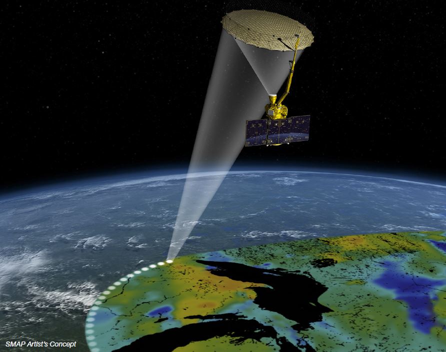
NASA put a satellite that included Michigan technology into space January 31, 2015 for the sole purpose of measuring soil moisture. The multifaceted goals of this ongoing mission, called Soil Moisture Active Passive (SMAP), are to improve weather forecasting, monitor droughts, predict floods, improve crop productivity, and measure the Earth’s water, energy, and carbon cycles. SMAP is NASA’s first Earth-observing satellite mission designed to collect global observations of surface soil moisture and its freeze/thaw state, data that have broad applications for science and society.
The equipment aboard the satellite is able to gather information about soil moisture in the top 2 inches of the Earths’ topsoil on a global scale every 2-3 days thanks to advanced remote sensing, a specialty of several faculty in the Department of Electrical Engineering and Computer Science.
Three of these faculty, Kamal Sarabandi, Rufus S. Teesdale Professor of Engineering, Prof. Leung Tsang, and Dr. Leland Pierce received a Group Achievement Award from NASA for their “outstanding contributions to the development of the Soil Moisture Active Passive mission and demonstration of its scientific and societal impact.”
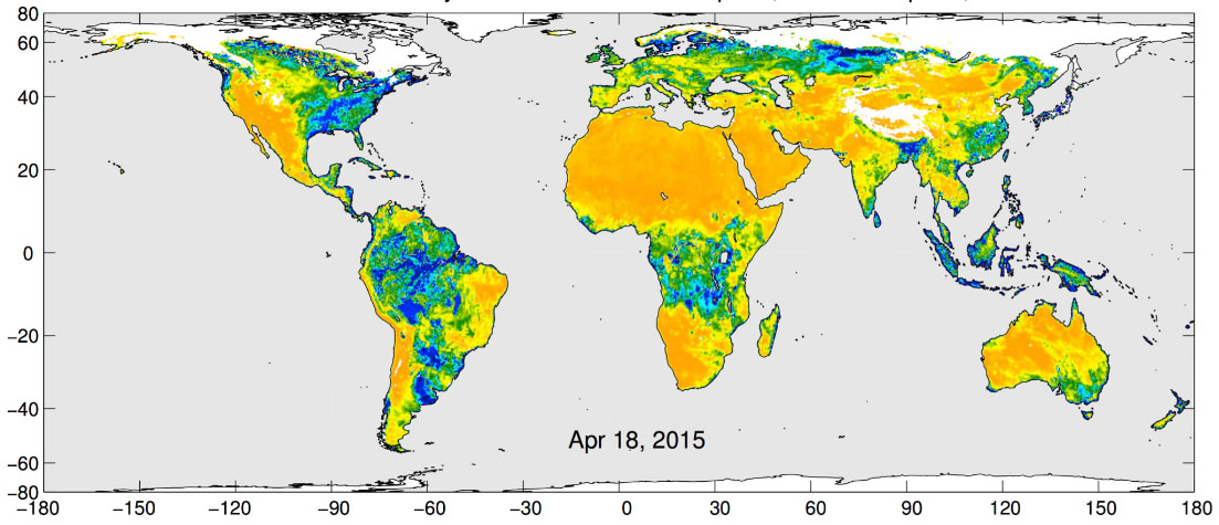
Since its launch, SMAP has led to new surface flooding maps of SE Texas and the Tennessee Valley following Hurricane Harvey, an entire year of soil moisture data that is yielding insights into the short and long-term impact of soil moisture on weather (including droughts and floods), and a complete recording of the presence of snow and ice at given times during the year. In addition, the radiometer aboard the satellite has been able to send data about extreme wind events such as hurricanes and cyclones. With data still coming in, scientists have now begun the process of interpreting the data.
 Enlarge
While SMAP is delivering on its promise of long-term global monitoring of the Earth’s soil moisture, Sarabandi regrets the loss of even more detailed information that would have been possible had a specially-designed radio not failed only months into the mission. The radar was meant to accompany the radiometer. [read more about the most powerful radar calibration device in the world created for this mission]
“The radar would have allowed a much higher resolution,” said Sarabandi. “The radiometer footprint is 30-40 km. With the radar, we could have had 1km resolution, allowing us to see the soil moisture variability much more finely.” The radar would also have made it possible to interpret snow and ice levels with much greater accuracy.
In addition, the radar and radiometer data were complementary. Scientists never had simultaneity of radar and radiometer before.
It seems the power supply of the power amplifier on the SMAP radar device failed.
Fortunately, by tweaking the algorithms that interpret the data, the radiometer is providing better information than originally anticipated.
In addition, the researchers looked for other opportunities to apply their specially developed algorithms that correlated both radar and radiometer data – such as looking at another satellite that has radar and combining that with the radiometer data that SMAP is still collecting.
Professor Tsang’s group has been using the European Space Agency (ESA) Sentinel satellite C band radar data for this purpose.
Tsang’s group has developed physical microwave scattering models that combine the radar from Sentinel with the L band radiometric signals of SMAP.
“Recent physical modelling based on full wave simulations is showing much larger microwave penetration through vegetation and forests than predicted by previous models,” said Tsang. “These new models encourage re-examination of data already collected, particularly over dense vegetation and forests.”
Data interpretation, gathering, and calibration will continue for the duration of the mission, which Sarabandi predicts should be another 3-4 years.
In the meantime, SMAP will continue to provide information that will, on a smaller scale, help farmers facing drought, and on a larger scale, help scientists better understand the presence and impact of water on the entire planet.